
Page 25 - 2018 Annual Report Council of Agriculture, Executive Yuan
P. 25
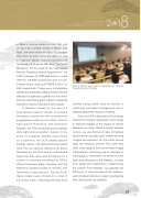
Annual Report 2018 Council of Agriculture, Executive Yuan in March, strong winds on April 23, hail on April 23, weather fronts in March and April, torrential rains on June 13, drought from April to June, torrential rains on July 2, Typhoon Maria, tropical low-pressure flooding on August 23, and Typhoon Mangkhut. On the basis of the “Agricultural Natural Disasters Relief Regulations” the COA arranged (i) NT$2.056 billion in cash relief for 56,908 households and (ii) low- interest loans totaling NT$639 million for 509 households. These were immediately distributed following a determination that the affected households quali�ed for this relief, and the relief had a great impact in assisting farmers to resume operations and rebuild. In addition, based on the use of a specialized weather model to analyze forecasts, combined with professional suggestions made by the COA’s District Agricultural Research and Extension Stations, the COA produced and broadcast daily agricultural weather videos. In the event of a special weather event (such as a typhoon), the COA added special weather videos. The aforementioned videos were not only used as reference for policy decisions by the COA and its subordinate agencies, they were also broadcast on a variety of channels including the COA’s official Facebook page, Youtube, and the electronic bulletin boards at farmers’ and fishermen’s associations. During 2018, these videos were clicked on a total of 4.9 million times, indicating that they were Staff at farmers associations upgraded their abilities through lectures and training. already being widely used by farmers in improving cultivation management and in disaster-prevention decision-making. Also, the COA’s Agricultural Technology Research Institute developed technology to interpret images of the impact of natural disasters on crops. When a natural disaster occurs, we use drones to take immediate aerial photos and get rapid remote-sensing images as evidence for the initial period after the disaster strikes. The COA also uses crop-lodging semi-automated image interpretation technology as an auxiliary to cartographic information to determine the land area affected by the disaster, in order to (i) assist local authorities in determining the extent of the disaster, (ii) upgrade the efficiency of local surveys of the disaster, and (iii) assist farmers to begin recultivating their land as soon as possible. 23
